Discover MapWeave
The revolutionary geospatial visualization SDK that uncovers every connection.
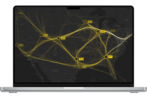
MapWeave, our new SDK for building map-based investigation and intelligence tools, is now generally available. It lets developers build market-leading apps that integrate map, network, timeline and observations data into an intuitive investigative workflow. For teams working with complex geospatial intelligence, it’s a game-changer – uncovering connections and patterns that were previously hidden across huge, fragmented datasets and tools.
Traditional GIS tools are great at showing where things happen – but not why. They weren’t built to help analysts understand changing connections between people, places and events.
MapWeave fills that gap. It’s our first SDK purpose-built for geospatial link analysis, designed to help users investigate:
Since launching the Early Access Program in March, we’ve worked closely with users in law enforcement, cyber security, fraud detection, and defense. Their feedback helped us shape MapWeave into a robust, flexible, and high-performance tool, ready for real-world deployments.
New features we’ve added since early access include:
MapWeave brings a richly interactive spatial dimension to our suite of graph and timeline SDKs. By integrating location context into complex investigations, it connects digital and physical data points to reveal patterns, relationships, and movements that would otherwise remain hidden – unlocking faster, more informed decisions across domains.
MapWeave is designed with developers in mind. It’s:
And because it integrates seamlessly with our other SDKs, you can build full-spectrum intelligence apps where maps, networks, and timelines work in harmony. “MapWeave brings a level of clarity to geospatial investigations that simply hasn’t been available to our customers before,” said Dan Williams, Chief Product Officer at Cambridge Intelligence. “It helps organizations in security, fraud detection, and intelligence get more from their data – faster, and with fewer barriers.”
Now it’s over to you. Whether you’re building tools for investigation, security, or analysis, MapWeave gives you a new, clearer way to visualize the story behind your data.
Start your free trial now, or get in touch for a personalized demo. We’ll show you how MapWeave – and our full suite of visualization toolkits – can transform the way you analyze spatial and temporal data. We can’t wait to see what you build.
The revolutionary geospatial visualization SDK that uncovers every connection.
Registered in England and Wales with Company Number 07625370 | VAT Number 113 1740 61
6-8 Hills Road, Cambridge, CB2 1JP. All material © Cambridge Intelligence .
Privacy Policy | Security Framework